
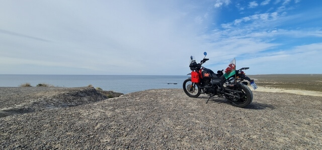
I’ve just returned from an eight-day, 3000km motorcycle adventure to Patagonia, Argentina and while I usually lean off-topic here on DCT, it is possible to describe the trip with at least some tech involvement, I promise you.
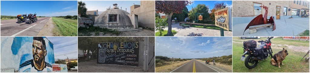
I had been planning the trip since last October when I remembered that I had a slice of Welsh slate, mined in Blaenau Ffestiniog and given to me by my sister who at the time was living in an idyllic 600-year-old house in West Wales. Anyway, the idea was to ride to Puerto Madryn, present it to the local Welsh Association and have a bit of fun along the way. I should point out that much of Patagonia was colonised by Welsh emigrants in 1865 following a three-month voyage aboard the schooner Mimosa out of Liverpool and since both my parents were born in Wales, I have a natural affinity for all things Welsh.
Planning The trip
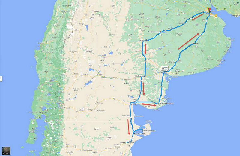
My first port of call was Google Maps which I use for all my route planning, so I was able to split the outward leg of 1450km into bite-sized 500km chunks. But one has to take the quoted journey times with a large pinch of salt when other factors such as coffee breaks are taken into account. A projected (by Google) journey of five hours will most likely end up as nine hours in my experience.

The journey above was 452km with a Google time of around five hours at 60km/h and although we were riding at an average speed of 100km/h, it still took us over nine hours. And Google Maps is much more than just mapping because it helped me find hostels and hotels, all of which have reviews, photos, dining suggestions, and a host of other useful information. For example, the first hotel was in Trenque Lauquen, an agricultural town straddling a major road to the interior and I chose it for the location, the price, and the restaurant next door, all for around $18 per night. Booking hotels can be a lottery, especially in the economy segment as we were doing. But this one turned out to be brand new, immaculate, and excellent value for money, not to mention the feast we enjoyed at the restaurant next door all cooked by our jovial host, Paco.
Navigation
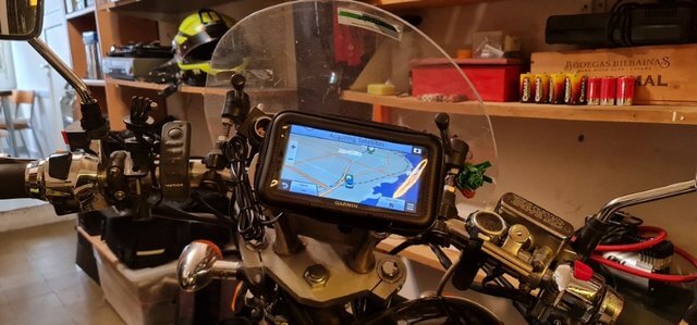
This is a sore point and I’ll explain why. For the last few years, I’ve been relying on a Garmin Nuvi 67 for my navigation because it ticks all the right boxes. It’s fast, accurate and it has a large, bright screen that I can see in all light conditions. However it’s now developed a fault where it won’t charge, so I acquired a Beeline Moto which is a completely different style of GPS design in that all it displays are indications of where and how you need to turn.

Using the Beeline app on my phone, I plan my route, and via Bluetooth, the device displays what I need to know.

Battery life is incredible and the system is very accurate indeed. The downsides are that Bluetooth sucks the juice from my phone’s battery and on reflection I much prefer a map in front of me. However, I rigged it up for the trip, but after several hundred kilometres, the vibrations broke the mount, the Beeline fell off and I was able to catch it just in time before it became roadkill.
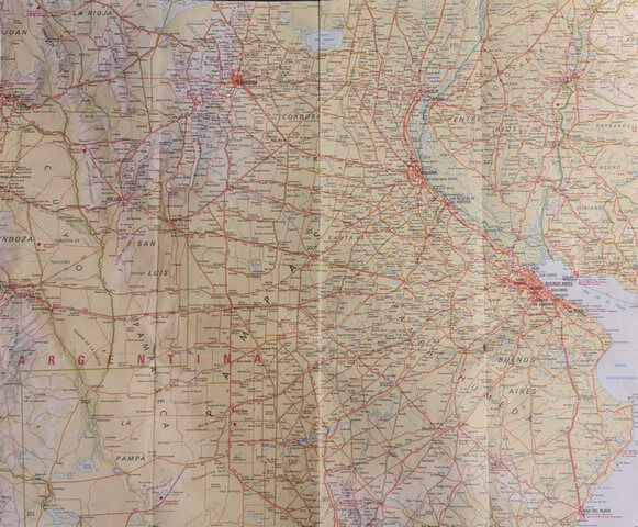
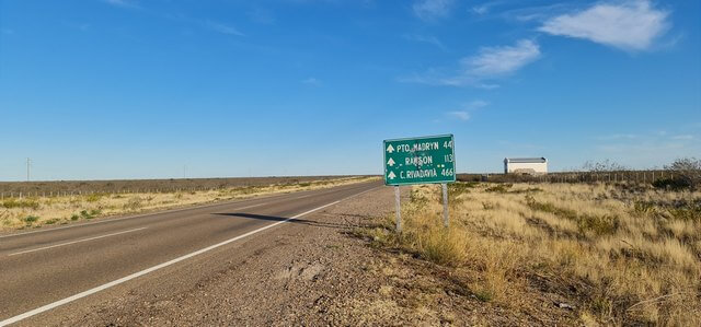
Believe it or not, I took along a real paper road map, something I haven’t done in years, and glanced at it from time to time on coffee breaks. But my main reference was always Google Maps and since most of the stretches were very straightforward – i.e., follow this arrow-straight road for 250kms – I could store the information in my head. Road signs in Argentina often don’t make sense because on some occasions I’d see a sign for Puerto Madryn being 44kms away and then half an hour later I’d be told it was 52kms, which made me chuckle.
My companion carried two phones with him which he hot-spotted together so that he could strap one to the handlebar and use Google Maps by leeching the data connection from the other phone. That’s something I may consider if I can find a cheap, used device.
Filming And Photos
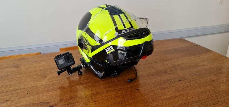
I took my GoPro Hero 5 strapped to my helmet and filmed as much as I could. However, I need to find a more streamlined placement for the camera because, at 100 kph, the force of the rushing air was pulling my helmet to one side. I ended up using it at much slower speeds when it wasn’t trying to rip my head off.
As for photos, I used my Samsung Galaxy Note 20 Ultra which takes some amazing photos like most phones nowadays, and with 1TB of OneDrive storage, I was able to upload through WiFi when at a hotel.
Unfortunately, we couldn’t keep stopping when a Kodak Moment appeared, which is a shame. If we had, we’d probably still be on our way back from Patagonia. However, here are a few that I managed to snap:
Charging Devices
Charging tech devices on the road is always a priority and if the vehicle isn’t fitted with a charger, you need to find something at a service station or hotel. Fortunately, I fitted a USB and 12v charger to the bike shortly after I bought it, so I could charge my phone on the move.

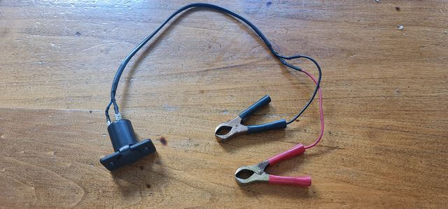
I would use the 12v output with my Garmin if I can ever get it repaired because Garmin insists on using their own original equipment, but don’t get me started on that, please. I also carry a 12v pump for punctures, but since the outlet won’t take 15 amps, I rigged up my own 12v cable arrangement which I can connect to the battery as and when I need it.
Apart from my vehicle registration number plate attempting to disintegrate and the incident with the Beeline, I was fortunate not to have any mechanical or other problems to deal with during the trip, My companion, Eduardo on the other hand, lost the backplate and two nuts from the part where you adjust the chain which luckily we spotted just in time. Things rattle free but we were vigilant in checking the bikes several times every single day.
It was a thoroughly rewarding trip and, to be honest, I can’t think of any other gadgets I would have taken with me. On a more basic note, I took a stainless steel (no glass) thermos flask along because all the service stations will gladly fill it with hot water for that essential cup of tea in the outback.

Talking of which, we often travelled on desert roads which were devoid of civilisation for 200kms at a time. Not exactly on the same level as Australia where you can come across signs that tell you that there’s no fuel for 500kms, but daunting and exciting nonetheless. Consequently, we made sure we filled our tanks up at every single opportunity.
—
Wonderful trip. Enjoyed reading about it.