Google Earth is really one of the most incredible programs I have ever come across. I don’t mean just as a mapping program because it is much more than that. I am talking about the power of Google Earth.
12 Easy And Cool Things
I am sure there are many more cool things to do while using Google Earth but here are some of my favorites.
- Visit your old school or home town
- Walk on the Moon, visit Mars or explore the universe.
- Preview your next vacation
- Use a flight simulator to fly over cities
- Get close up views of places in the news
- View beautiful user submitted photographs
- Take Preset Guided tours of interesting places
- Use it to enhance your business, get demographics, traffic flow, etc.
- Dive to the ocean depths, visit underwater canyons of find shipwreck locations.
- Follow the path of famous explorers like Lewis and Clark, the Shackleton expedition, Hillary’s climb on Mount Everest, Henry Hudson, Captain Cook or Marco Polo to Christopher Columbus
- Travel back in time. Many locations not only give current views but go as far back in time as 1930.
- Change the time of day in any location.
What is Google Earth
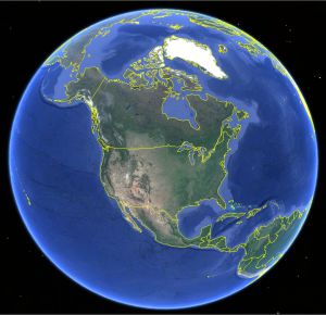
Let’s start with a description of what Google Earth is. It is a virtual globe that uses satellite imagery, airplane photography, and street view video from Google’s vast database. Data is added daily.
You are not restricted to a topographical view (like looking at a paper map) of the earth but actual photographs in stunning 3D. To be honest, you are not even restricted to Earth. The name “Google Earth” might have been given a bit early because you may use it to explore the Sky, walk on the Moon, or visit Mars, if you insist on staying on planet earth, you can dive in the ocean and visit the deepest underwater canyons.
Google Earth has changed over time and when they offered the “Basic” version free for desktop users most professionals thought it was too good to be true and waited to see how long that lasted. Google surprised a lot of people not only keeping it free but recently offered the “Pro” version free. The extra features contained in the pro version are, to be truthful, a little more than an average user would need and covering all of the differences are too numerous to list in this post.
However, I would like to point out some of the enhanced features:
Home users now have the faster performance that the Pro version offers as well as the ability to print images in 4800 pixels compared to the 1000 in the basic version. Now you may even create premium movies with Google Earth Pro. A couple of extra features include the ability to measure in the Pro version; get the area of a circle, measure the height of a building, or measure the distance between two points. The Pro version even has access to city demographics, parcel information and traffic counts.
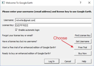
Getting Google Earth
Simply type earth.Google.com in your browser or click here. Two versions will be offered and if you wish you may compare a list of features between the two. If your computer can handle it, and anything less than five years old should, I suggest you get the Pro version. Enter your username, and GEPFREE as the license key Choose Free Trial and then Click on Log In to open the program.
How To Navigate Google Earth
There are several ways to navigate in Google Earth. The navigating tool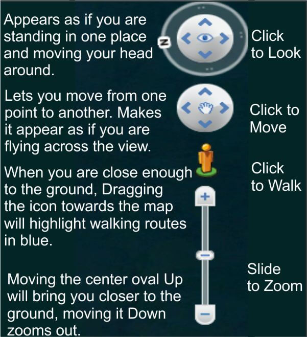 s are easy to learn and make moving around fast and easy. The look option gives the appearance of standing in one place and swiveling your head to look around. The move option lets you fly over the landscape or navigate sidewalks in street view.
Whenever you are close enough to the ground, you may choose the “Man” icon, when you do, blue lines will appear on the map, placing the icon on the blue line will put you in street view. Finally, the zoom slider zooms in or out.
As easy as the navigation tools are, most users quickly learn other ways to navigate. Some features depend on your current view. For example in regular view, use the mouse wheel to zoom in or out, in the street view use it to move along a path.
Other options include “click and pull” to pan across an image, double clicking will zoom in. I find the arrow keys on the keyboard are the best way for walking along a path in street view.
Google Earth Tools
Google Earth offers several tools for exploring and using the program. This is not actually a tutorial on how to use Google Earth, just an introduction to the program but covering some the tools will get you up and running faster.
The standard toolbar choices are available that are similar to all programs but most of the choices unique to Google earth are also available in the Icon Toolbar View. Most of the Icons are self explanatory, I have given a brief description below but have followed it with some detailed highlights on some of the really cool tools.
![]()
- The search is pretty obvious, you may enter any location and immediately go there.
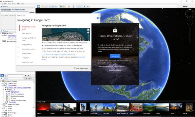
- The next icon adds or removes the left column from the screen. (See the first image in this post)
- The push pin lets you place a marker wherever you wish on the map.
- The polygon and path tools are next. They allow you to draw right on the map
- The Image Overlay lets you overlay a photo or drawing over the current image on the map.
- The Camera allows you make a movie like a guided tour for exporting.
- The clock will place a slider on the screen if you are in an aerial view that will allow you to see the landscape as it was at an earlier date.
- The sun icon will let you see some views at different times of day.
- The Saturn icon will let you choose the Earth, Sky, Mars or the Moon views.
- The ruler will give you the true measurement of the polygon, paths or lines you have drawn on the map.
- The final four icons will let you mail, print, save the current image or send you to Google maps.
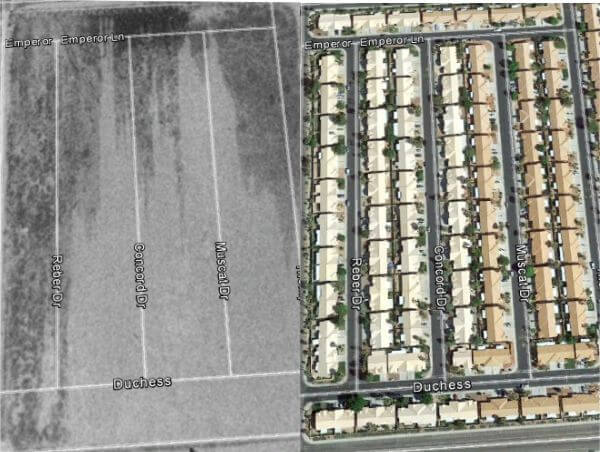
Google Earth Historical Views 
The Time slider (above) will show you historical aerial views. Some views go back as far as 1930 but most only go as far back as 1978. Of course, the quality of the older photos are not always the best but it is a great tool for history buffs. You may watch a city grow over time. I personally use it to look for sites where buildings were standing at an earlier time and now it is empty land. I find that great for using my metal detector.
Google Earth Layers
The layers functions are some of the best features in Google Earth. Unfortunately, th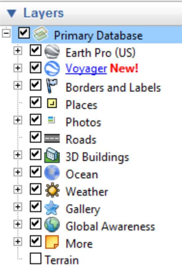 ere is not enough room to show you all the effects the layers have on the map but they are pretty impressive. Click on any of the + symbols and open up additional choices. There are over 150 different layers available.
What to see all the Park And Recreation Areas? No problem you may click golf courses, Fish and Wildlife, National Parks and More.
The “Place Categories will let you view where every type of retail establishment is on the map, from Bars to Banks and Pharmacies to Hospitals. The Transportation section show all the airports, railways and bus routes and many more.
You may even select Wikipedia, or National Geographic. These will show any locations that have been reviewed by these organizations.
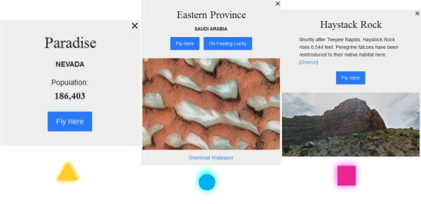
While there is a lot more I wanted to highlight the category under Voyager, in this area you may select special Street View highlights, Earth View landscapes, 3D Cities and more. Each brings a new level of view to the map.

In this map section, the Yellow Triangles show cities available in 3D and gives you the option of Flying there. The blue dots are Earth View landscapes and some are available as Wallpaper, the third view, the magenta dots are Street View Highlights. These are actually ground views of selected items in a landscape or city.
 Summary
Obviously, there is just too much to show in a blog about this program and I encourage you to give it a try. Take one of the guided tours. Focus your interests by selecting one or more of the layers.
 If you are into nature click on the national Geographic Magazine layer and get detailed information on highlighted areas.
If your into history, use the time bar to see in the past or click on the Rumesy Historical Maps Layer to view historical maps of highlighted areas. The program lays the historical map directly over the current view giving a cool comparison of the old and new.
 Join the Google Earth Community and add your own photos to share with others. I guarantee you will love this program or receive a 100% refund.
Enjoy,
Jim
Nice one Jim,
Google Earth is great and the feeling of ‘being there’ in different parts of the world is almost like a physical visit…….(simply by hanging on to a mouse)…….(-:
Google Earth is in itself a wonderful application. The problem here is that, as all Google products, it installs itself together with its brood … google update service, google folders & files and registry keys… I’ll stick on Google Maps here. No Mars, no Moon, so many less features than Google Earth of course, but I just cannot bear applications which flood one’s system.